Floodplain Overlay District
 The Floodplain Overlay District is a zoning overlay district. A zoning overlay is a zoning district that is applied over one or more previously established zoning districts. The purpose of a zoning overlay is to establish additional and/or stricter zoning standards within that particular area.
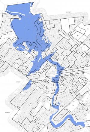
The overlay district as illustrated (right; in blue) is identifical to the 100 year floodplain as mapped by FEMA on the 2006 Floord Insurance Rate Map. (For more information on mapping, please visit the Flood Maps page). The intent of the overlay district is to:
- Discourage construction and regrading in flood areas;
- Prevent encroachment into the into high hazard areas that would obstruct the movement of water;
- Prevent pollution of waterways during low- or high-water periods;
- Prevent the loss of property and life and the disruption of commercial and government services.
How does the floodplain overlay district help Township staff to achieve these goals?
It allows us to regulate uses, activities, developments, and improvements which may contribute to increasing flood heights, velocities, and/or frequencies. Additionally, it gives us the ability to limit certain kinds of uses and activities in high risk areas so as to prevent or limit the unnecessary loss of life or property.
Township staff pays special attention to development and improvements to properties located in the floodplain. The reason is obvious. By ensuring that any and all improvements to properties that are at risk to flooding are completed responsibily with the rest of the Township and our neighboring communities in mind; we are able to help mitigate the negative impacts of the next flood.
This includes proposed improvements that qualify as a substantial improvement. A substantial improvement is one which costs more than 50% of the structures market value. Market value is determined by taking the assessed improvement value of the property (does not include assessed land value) and dividing it by the equalization ratio for the Township. As of April 2020, the equalization ratio for the Township is 35.08%. If an improvement is deemed to be a substantial improvement, it must be brought into compliance with all applicable building codes as well as the Township's Flood Damage Prevention Ordinance (§225 of the Township Code). Additionally, all substantial improvements in the floodplain require approval from the Township's Zoning Board of Adjustment. These rules apply to structures that have been substantially damaged as well. Substantial damage is defined as "damage of any origin sustained by a structure whereby the cost of restoring the structure to its before-damaged condition would equal or exceed 50% of the market value of the structure before the damage occurred."
If you are considering improvements to your property and you are located in the floodplain, please be sure to review the restrictions and requirements for propertites located in the Floodplain Overlay District (§255-36G - Use Regulations; Floodplain Overlay District).
Updated March 7, 2020
